Technical Policy Briefing Notes - 8
Social Network Analysis
Case Studies
Policy Briefs
Social Network Analysis
Case Studies
The MEDIATION study has reviewed existing literature examples and has applied network analyses
to a number of adaptation case studies (see Varela-Ortega et al., 2013, Bharwani et al. 2012, Zhu
and van Ierland, 2013 for more details). The case studies are summarised in the box below.
Case
Study 1 – Quantitative Social Network Analysis in Finland
The first MEDIATION case study, focusing on Finland, used egocentric SNA to investigate farmers’ involvement in environmental conservation through their relationships with other actor-types, i.e. with conservation stakeholders. The research was investigating the effectiveness (for the local ecology and economy) of agri-environmental schemes (AES), and their role as potential adaptation options in the context of future climate change. These schemes are an existing policy instrument for enhancing biodiversity in Finnish agricultural landscapes, promoting active management and maintaining the conservation values of semi-natural grasslands and other traditionally managed biotopes.
A survey was sent to farmers in two locations (SW Finland and Pirkanmaa), most of whom had an agro-environmental agreement (AEA) in place. The survey collected information about farming practices, farmer attitudes towards conservation, and other farmer attributes. It also included a section (related to SNA) which asked whether they had a connection or not to each of 14 different actor categories. The response rate was 20%, with just under 400 answers, with over 250 of these fully completing the survey section on their networks.
The network analysis method was adapted to understand the role of different organisations in the communications about adoption of AEAs and the channels of potential influence and dissemination. Information about networks was included as an attribute, and was used to visualise and to make statistical comparisons across several other variables.
While a complete network and structure properties could not be constructed from the responses, because connections were directed to categories of actors/ actor-types rather than individually (uniquely) identified actors, the survey provided important information on individual networks.
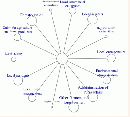
The overall set of responses were analysed calculating the proportion of farmers having a connection with each actor type. Several actor groups had an overall connectivity of > 80% (administration of rural affairs, Forestry Union, Other farmers and forest owners and local hunters).
Figure 2 shows results presented using R statistical software (R Core Team, 2012) and its packages for network analysis and visualisation (Csardi and Nepusz, 2006).

Figure 2 Caption-size of node
labels and size of node is
scaled to proportion farmers of connections.
scaled to proportion farmers of connections.
Subgroups in the farmer responses
were analysed and compared. Subgroup categories were farm location
(alternatives were SW Finland and Pirkanmaa), farm type (alternatives
were animal husbandry and crop) and type of AEA (alternatives were
normal and special). Differences among each pair of alternatives were
assessed visually, by comparing network diagrams, and statistically, by
using Chi-squared tests of differences in the proportions. The tests
showed that, significantly,
Case Study 2 – Qualitative Social Network Analysis in Spain
The second case study focused on Guadiana river basin, presenting an illustrative example of adaptation decision-making in the agricultural and water sectors (see Varela-Ortega et al., submitted). This basin is expected to be one of the most seriously affected by climate change in Spain, with a potential decrease in water resources of 11% by 2030 and associated impacts on irrigated agriculture. A social network mapping exercise was undertaken to analyse the social and institutional framework of climate change adaptation. This was applied to a group of basin stakeholders: the water administration, representatives of the main irrigation communities, active environmental groups and the different climate change offices involved in the basin (National and Regional). The analysis focused on ‘how are climate change adaptation related decisions taken in the Guadiana basin, in the agricultural and water sectors?’
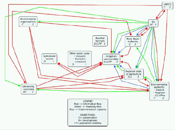
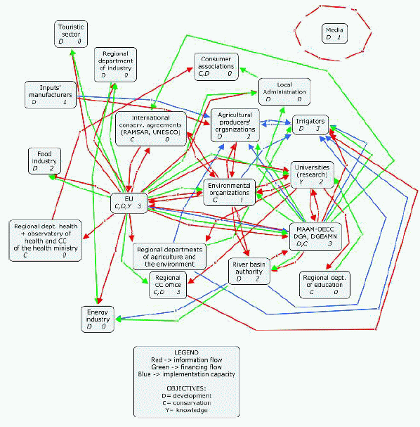
A stakeholder workshop was used, grouping attendees into water administration, farmers and environmental / CC organizations. Each group built a socio-institutional network map, which were subsequently discussed to help learning of all perspectives. Each box represents a different stakeholder group (name, main objective, and influence [where a higher number indicates higher influence]). The linkages represent flows of information, funds and implementation capacity between stakeholder groups.
The network map of water administration officers was a hierarchical network structured in several blocks of actors: administrations, water users (agrarian and non-agrarian uses), trade unions, scientific community and environmental organizations, with the administrations clustered in the middle. The number of links is quite high, showing a strong relationship between actors (a ‘discourse coalition’ (Turnpenny et al, 2005) with a ‘shared world view’ or Type 3 network where uncertainty can be explicit, although it tends to be embedded in how the organization is structured and procedures in place .

The discussion revealed that to improve these relationships, there would need to be more willingness to solve problems, increased participation, resources to backup compulsory environmental regulations and improved connections. The group also provided information on changes in the social-institutional framework that could improve decision-making for climate change adaptation.
The network map of farmer representatives (from irrigation communities and independents) was very different, and was more fragmented with a lower number of connections and some disconnected actors. They identified different groups and had different perceptions. This is a Type 1 type of network where individual action predominates. Adaptation was considered from a local and independent perspective, with a diversity of approaches to uncertainty, and is highly constrained and mostly short-term in nature. The discussion on how to improve the system included an increase in trust, the exploration of synergies, and for key links to be improved. This reflects an ‘advocacy coalition’ with a shared worldview but where technical approaches differ (Turnpenny et al, 2005).

A number of missing connections were also identified, as well as a need for more capacity for decision-making and action, training, implementation capacity and funding between the irrigation communities.
Finally, the members of environmental NGOs and climate change officers designed a homogeneous network, with no evident clusters. The number of links between actors is high, and none of them is disconnected.
This is a Type 2 egalitarian network where everyone tends to be ‘likeminded’ and the structure of the problem is similar across the network. Uncertainty may not be explicit but reduced to tacit assumptions and reflected in cultural and group norms rather than a science-policy dialogue. The goals of the different actors reveal two important conflicting objectives in the network: conservation and development. The group suggested synergies by developing tools and strategies with co-benefits for both objectives, raising awareness about climate change and continuing to involve the media.

Comparing the three networks, the groups identified two main groups of actors: water users and policy makers. However, there were important differences: the water users network had a big emphasis on agricultural uses. All groups identified the multiple scales (local, regional, national, European) and different sector, but the farmers had a more partial view of the system with a lower number and less detailed actors. Only one group (the environmental network) identified the media as an actor.
There are also differences in the flows across the three networks. Stakeholders from the water administration perceived themselves as the main information providers in their network, with a cascade from regional and national administration. Farmers perceived reciprocal flows (two-way arrows), but considered environmental organizations and scientists as main information providers. The environmental actors considered the main information provider was the EU followed by environmental organizations and universities, but via different channels. Similarly, the maps reveal differences on the financial flows and implementation capacity between the groups. The strength and number of connections (lines) in the maps also show important differences. These also indicate the influences, though all groups consider the most influential actors were the EU, the national government and the regional government, together with irrigators. Finally, the groups all identify conflicting objectives of conservation/environmental protection and development/economic benefits, though the different groups had different views on which should be prioritised.
Overall, the exercise revealed important differences between the three networks. While the water administration was focused on a traditional top-down approach to decision-making, with a hierarchical structure to other actors, agricultural users (irrigators) had an individualistic view of the process. The environment and climate change representatives had the most holistic approach and deepest understanding of the adaptation process, with highest representation of stakeholder groups in their network diagram. All agree on the influential actors and those with most influence for adaptation. The figure illustrates key omissions and connections (i.e. weak lines to improve). The mapping was discussed by the stakeholders and used to highlight and find ways to overcome barriers.
The workshops helped to increase awareness and brought attention to the current weakness of the socio-institutional framework and areas to explore, as well as bringing the different groups together, helping to identify steps to improve linkages and information flows.
- farmers in Pirkanmaa were more connected to local forest management than farmers in SW Finland
- farmers with special AEA were more connected to environmental administration and less connected to local industry than farmers with normal AEA
- farmers involved in animal husbandry were more connected with the Union for agriculture and forest producers than farmers involved in crop agriculture.
Case Study 2 – Qualitative Social Network Analysis in Spain
The second case study focused on Guadiana river basin, presenting an illustrative example of adaptation decision-making in the agricultural and water sectors (see Varela-Ortega et al., submitted). This basin is expected to be one of the most seriously affected by climate change in Spain, with a potential decrease in water resources of 11% by 2030 and associated impacts on irrigated agriculture. A social network mapping exercise was undertaken to analyse the social and institutional framework of climate change adaptation. This was applied to a group of basin stakeholders: the water administration, representatives of the main irrigation communities, active environmental groups and the different climate change offices involved in the basin (National and Regional). The analysis focused on ‘how are climate change adaptation related decisions taken in the Guadiana basin, in the agricultural and water sectors?’
A stakeholder workshop was used, grouping attendees into water administration, farmers and environmental / CC organizations. Each group built a socio-institutional network map, which were subsequently discussed to help learning of all perspectives. Each box represents a different stakeholder group (name, main objective, and influence [where a higher number indicates higher influence]). The linkages represent flows of information, funds and implementation capacity between stakeholder groups.
The network map of water administration officers was a hierarchical network structured in several blocks of actors: administrations, water users (agrarian and non-agrarian uses), trade unions, scientific community and environmental organizations, with the administrations clustered in the middle. The number of links is quite high, showing a strong relationship between actors (a ‘discourse coalition’ (Turnpenny et al, 2005) with a ‘shared world view’ or Type 3 network where uncertainty can be explicit, although it tends to be embedded in how the organization is structured and procedures in place .

The discussion revealed that to improve these relationships, there would need to be more willingness to solve problems, increased participation, resources to backup compulsory environmental regulations and improved connections. The group also provided information on changes in the social-institutional framework that could improve decision-making for climate change adaptation.
The network map of farmer representatives (from irrigation communities and independents) was very different, and was more fragmented with a lower number of connections and some disconnected actors. They identified different groups and had different perceptions. This is a Type 1 type of network where individual action predominates. Adaptation was considered from a local and independent perspective, with a diversity of approaches to uncertainty, and is highly constrained and mostly short-term in nature. The discussion on how to improve the system included an increase in trust, the exploration of synergies, and for key links to be improved. This reflects an ‘advocacy coalition’ with a shared worldview but where technical approaches differ (Turnpenny et al, 2005).

A number of missing connections were also identified, as well as a need for more capacity for decision-making and action, training, implementation capacity and funding between the irrigation communities.
Finally, the members of environmental NGOs and climate change officers designed a homogeneous network, with no evident clusters. The number of links between actors is high, and none of them is disconnected.
This is a Type 2 egalitarian network where everyone tends to be ‘likeminded’ and the structure of the problem is similar across the network. Uncertainty may not be explicit but reduced to tacit assumptions and reflected in cultural and group norms rather than a science-policy dialogue. The goals of the different actors reveal two important conflicting objectives in the network: conservation and development. The group suggested synergies by developing tools and strategies with co-benefits for both objectives, raising awareness about climate change and continuing to involve the media.

Comparing the three networks, the groups identified two main groups of actors: water users and policy makers. However, there were important differences: the water users network had a big emphasis on agricultural uses. All groups identified the multiple scales (local, regional, national, European) and different sector, but the farmers had a more partial view of the system with a lower number and less detailed actors. Only one group (the environmental network) identified the media as an actor.
There are also differences in the flows across the three networks. Stakeholders from the water administration perceived themselves as the main information providers in their network, with a cascade from regional and national administration. Farmers perceived reciprocal flows (two-way arrows), but considered environmental organizations and scientists as main information providers. The environmental actors considered the main information provider was the EU followed by environmental organizations and universities, but via different channels. Similarly, the maps reveal differences on the financial flows and implementation capacity between the groups. The strength and number of connections (lines) in the maps also show important differences. These also indicate the influences, though all groups consider the most influential actors were the EU, the national government and the regional government, together with irrigators. Finally, the groups all identify conflicting objectives of conservation/environmental protection and development/economic benefits, though the different groups had different views on which should be prioritised.
Overall, the exercise revealed important differences between the three networks. While the water administration was focused on a traditional top-down approach to decision-making, with a hierarchical structure to other actors, agricultural users (irrigators) had an individualistic view of the process. The environment and climate change representatives had the most holistic approach and deepest understanding of the adaptation process, with highest representation of stakeholder groups in their network diagram. All agree on the influential actors and those with most influence for adaptation. The figure illustrates key omissions and connections (i.e. weak lines to improve). The mapping was discussed by the stakeholders and used to highlight and find ways to overcome barriers.
The workshops helped to increase awareness and brought attention to the current weakness of the socio-institutional framework and areas to explore, as well as bringing the different groups together, helping to identify steps to improve linkages and information flows.
 download this briefing note