“While conventional methods are not able to yield a reasonably reliable El Niño prediction more than six months before the event, our method at least doubles the warning time,” says Armin Bunde of Justus-Liebig-Universität Gießen (JLU) who along with his colleague Josef Ludescher led the study. The team detected evidence for the current El Niño already in September 2013. Their forecast appeared in the Proceedings of the US National Academy of Sciences in February 2014, and was now proven to be right.
Predictions by other, much bigger models wobbled up and down and as late as November 2014 gave a likelihood of only 58 percent that an El Niño will arrive. In contrast, the new and early forecast was stable over the whole period before the event and provided a significantly higher probability of 75 percent. The US National Oceanic and Atmospheric Administration only recently declared that El Niño arrived – the event started last year, but it has to last for some time to be officially recognized. Japan’s weather bureau saw the conditions fulfilled in December last year.
Impacts can hit hard on farmers and fishermen
The current El Niño is very weak and will likely not have the devastating impacts it had in other years. Yet some experts think that the tropical cyclone that sadly hit Vanuatu might now enhance westerly winds in the Pacific region – and this in turn might strengthen the El Niño. Remarkably, the new methodology was able to correctly anticipate the phenomenon despite the weak signal; it cannot predict the strength or duration of the event.
Peruvian fishermen dubbed the irregular warming of the Eastern Pacific ‘El Niño’, Spanish for ‘the Christ child’ or literally the ‘boy child’, because it usually appears every few years at some time around Christmas when the birth of Jesus is celebrated. It is part of a more general pattern of the Pacific ocean-atmosphere system called ENSO, which includes anomalous cold episodes called La Niña. In the past, it linked for instance to empty fishing-nets in Peru, but also floods in Ecuador and droughts in Australia, thus affecting farmers.
Advancing insight into how the phenomenon comes about
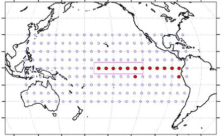
“The causes of this phenomenon are so far poorly understood – our methodology might now be the key to open a door to gain insight into the intricate mechanisms that trigger El Niño,” says Hans Joachim Schellnhuber, co-author of the study and director of the Potsdam Institute for Climate Impact Research. “Using data from more than 200 points in the Pacific, we see how interactions between distant sites are building up over time in the ocean-atmosphere-system, bringing about the warming events. It is like an orchestra of 200 musicians playing together. If the different regions in the Pacific are rather playing their own tunes, like soloists, no El Niño develops. So this is what we use to derive our warning. There's a harmony building up – which collapses when the event finally arrives. So physically this might be a resonance phenomenon.”
„What we do, using modern network approaches, is at the crossroads of mathematics and physics,“ says co-author Shlomo Havlin of the Bar-Ilan University of Israel. “When we used this data to hindcast El Niños of the past, we found that the alarms are correct in three times out of four – which is a lot, given the complexity of the phenomenon. Moreover, the algorithm our team developed already correctly predicted in 2011 that in 2012 there would be no El Niño, while officials up to September of that year said there would be such an event.” The scientists will now seek to further develop their methodology. The aim is to integrate more data in order to be able to forecast even the strength and the duration of the El Niños to come.
Article in which the warning for the current El Niño is published: Ludescher, J., Gozolchiani, A., Bogachev, M.I., Bunde, A., Havlin, S., Schellnhuber, H.J. (2014): Very early warning of next El Niño. Proceedings of the National Academy of Sciences [DOI: 0.1073/pnas.1323058111]
Weblink to this article: www.pnas.org/content/early/2014/02/07/1323058111
Article in which the methodology is published: Ludescher, J., Gozolchiani, A., Bogachev, M.I., Bunde, A., Havlin, S., Schellnhuber, H.J. (2013): Improved El Niño frorecasting by cooperativity detection. Proceedings of the National Academy of Sciences [DOI:10.1073/pnas.1309353110]
Weblink to this article: www.pnas.org/cgi/doi/10.1073/pnas.1309353110
For further information please contact:
PIK press office
Jonas Viering, Sarah Messina
Phone: +49 331 288 2507
E-Mail: press@pik-potsdam.de
Twitter: @PIK_Climate
Prof. Dr. Armin Bunde
Institut für Theoretische Physik der Justus-Liebig-Universität Gießen (JLU)
Telefon: +49 641 99-33375
Mobil: +49 157 33 14 55 55
E-Mail: arminbunde00@googlemail.com


