What does the model do? 
SWIM was specifically developed to investigate climate and land use change impacts at the regional scale, where the impacts are manifested and adaptation measures take place. The model simulates interlinked processes at the mesoscale such as runoff generation, plant and crop growth, nutrient and carbon cycling, and erosion. It provides numerous model outputs such as river discharge, crop yield, and nutrient concentrations and loads. The approach allows simulation of all interrelated processes within a single model framework at a daily time step using regionally available data (climate, land use and soil) and considering feedbacks. The model setup and postprocessing are supported by a GIS interface (based on GRASS). The model uses 3-level disaggregation scheme: basin – subbasins – hydrotopes. The results are presented as time series and maps for a number of variables. SWIM is a model of intermediate complexity for the river basin and regional scale, because it is a) more comprehensive than purely hydrological and precipitation-runoff models due to a more reliable representation of interlinked hydrological, vegetation and nutrient processes; b) driven by commonly available regional data and can be easier parametrized than more complex hydrological models.
Who maintains it?
SWIM is maintained and further developed by the regional hydrological modelling group of Research Department 2 on PIK's own GitLab source code repository. The development is coordinated by Michel Wortmann, Stefan Liersch and Fred Hattermann.
In what way is the model different from other models in the community?
- simulation of hydrological cycle (water discharge, groundwater level): the same or better than in other comparable ecohydrological and hydrological models;
- simulation of hydrological cycle at the river basin scale: better and more detailed process description than in the continental-scale terrestrial models, and in large-scale water resources models;
- simulation of vegetation processes: better than in many hydrological models, which normally do not consider dynamical vegetation processes;
- the latter are important in climate change studies due to interrelations between water and vegetation processes;
- simulation of water quality: better than in conceptual hydrological models which have no (or only minor) representation of soil processes;
- simulation of diffuse pollution: better than in other commonly used models because of a better temporal and spatial resolution and consideration of dynamical landscape processes;
- simulation of land use, agriculture management, crop yields and feedbacks of climate and land use changes: better than in other models with reduced representation of vegetation growth processes.
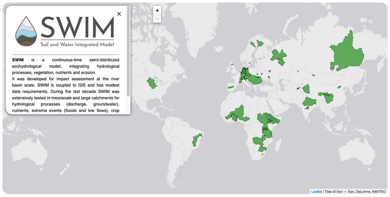
Where is the model currently applied?

Key publications
Krysanova, V., F. Hattermann, Sh. Huang, C. Hesse, T. Vetter, S. Liersch, H. Koch and Z. W. Kundzewicz, 2014. Modelling climate and land use change impacts with SWIM: lessons learnt from multiple applications. Hydrological Sciences Journal, accepted.
Krysanova, F. Wechsung, J. Arnold, R. Srinivasan, J. Williams, 2000. PIK Report Nr. 69 "SWIM (Soil and Water Integrated Model), User Manual", 239p. SWIM_Manual
Krysanova, V., Mueller-Wohlfeil, D.I., Becker, A., 1998. Development and test of a spatially distributed hydrological / water quality model for mesoscale water-sheds. Ecological Modelling, 106, 261-289.
Further reading
SWIM preprocessing GRASS modules m.swim (documentation and code repository)
SWIM Python interface and commandline tools (documentation and code repository - login required)


